As the Moon crossed between the Sun and Earth during the 2023 annular solar eclipse, its shadow darkened skies across the United States.
The Moon’s Shadow
An annular solar eclipse was created on October 14, 2023, when the Moon, Sun, and Earth were in alignment. Millions of Americans witnessed the spectacle as the Moon obscured the Sun’s rays, casting them in a lunar shadow.
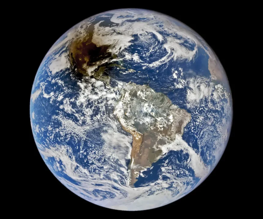
When the Moon crosses in front of the Sun but is too far away from Earth to totally block it out, an annular eclipse takes place. During an annular eclipse, when the Moon is at or near its apogee, or farthest point from Earth, it appears smaller in the sky. As a result, the Sun’s borders are seen as a reddish-orange ring known as the “ring of fire.” The incident was seen from Earth by a satellite as the Moon’s shadow moved across North America.

During an eclipse, two shadows are cast. The first is called the umbra (UM bruh). This shadow gets smaller as it goes away from the sun. It is the dark center of the eclipse shadow. The second shadow is called the penumbra (pe NUM bruh). The penumbra gets larger as it goes away from the sun. Credit: NASA
NASA’s EPIC (Earth Polychromatic Imaging Camera) imager on board DSCVR (Deep Space Climate Observatory), a joint NASA, NOAA, and U.S. Air Force satellite, captured the image above during the eclipse. From its location at Lagrange Point 1, a gravitationally stable point approximately 1.5 million kilometres from Earth, the sensor offers regular views of the whole planet. This image was taken at 16:58 Universal Time, or 11:58 a.m. Central Daylight Time, and shows the moon’s umbra, or shadow, descending over Texas’ southeast coast close to Corpus Christi.
ALSO READ :The Secret Code Of Nature: The Way Plants “Speak” Through The Air Via VOC

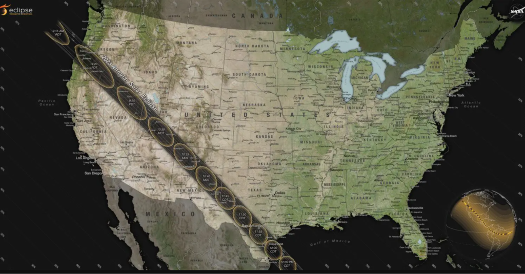
The path of annularity and partial contours crossing the U.S. for the 2023 annular solar eclipse occurring on October 14, 2023. Credit: NASA’s Scientific Visualization Studio
The greatest site to see the annular eclipse was along the path of annularity, which is where the majority of the Sun was obscured by the Moon from the spectators’ point of view, even though it was partially visible throughout the United States, Mexico, and Central and South American countries.
The black path of the annularity is depicted on the map above, created by NASA’s Scientific Visualisation Studio, and it crosses the lower 48 states from Oregon to Texas. Datasets from multiple NASA spacecraft are used in the map. The Blue Marble Next Generation composite, which was used to represent the topography, was created using imagery from MODIS (Moderate Resolution Imaging Spectroradiometer) instruments on the Terra and Aqua satellites.
At around 9:13 a.m. Pacific Daylight Time, the path of annularity began in Oregon, however some sky watchers were unable to see it due to hazy skies. The shadow then passed across Texas and the Gulf of Mexico before heading southeast into Nevada, Utah, Arizona, Colorado, and New Mexico.
Duration contours are also displayed on the map within the path. These indicate how long annularity persisted. The duration of the solar eclipse increased with proximity to its centre of path. Time intervals for the annular path vary from a few seconds at the periphery to a maximum of around 4.5 minutes in the core.
June 21, 2039, is when the next annular solar eclipse will be observed from the United States. On Monday, April 8, 2024, however, a total solar eclipse will cast a shadow over the skies from Texas to Maine.


